• Home
  • About
  • Insights
  • Book
  • Contact
  • Agriculture
  • Specialty Agriculture
  • Golf Courses
  • Case Study - Agriculture
  • More
    • Home
    • About
    • Insights
    • Book
    • Contact
    • Agriculture
    • Specialty Agriculture
    • Golf Courses
    • Case Study - Agriculture
Book now
  • Home
  • About
  • Insights
  • Book
  • Contact
  • Agriculture
  • Specialty Agriculture
  • Golf Courses
  • Case Study - Agriculture
Book now

Golf Course Drone Imaging and Turfgrass Analysis

Aerial view of a golf course fairway, green, sand bunker, and surrounding managed turf.

Terra Intelligence provides drone-based turf analysis and multispectral imaging for golf courses across Wisconsin. We help superintendents identify turf variability, potential stress, irrigation inconsistencies, and areas that may require closer ground inspection across greens, fairways, tee boxes, and other managed turf. Services can be customized for individual holes, targeted problem areas, or full-course monitoring, with options for one-time assessments or recurring scans throughout the season.

What We Analyze

Turf Health and Variability

Irrigation and Moisture Patterns

Irrigation and Moisture Patterns

Multispectral imagery can reveal differences in turf vigor across greens, fairways, and tee boxes, helping identify areas that may warrant closer inspection for stress, irrigation variability, or other turf-related concerns.

Irrigation and Moisture Patterns

Irrigation and Moisture Patterns

Irrigation and Moisture Patterns

Multispectral imagery can help identify potential overwatering, underwatering, drainage concerns, and uneven irrigation coverage across managed turf, helping superintendents prioritize areas for closer ground inspection.

Vegetation Indices

Targeted Problem Areas

Targeted Problem Areas

Terra analyzes NDVI, NDRE, and other vegetation indices to evaluate turf condition and highlight spatial differences that may not be apparent from ground level. These patterns can help identify areas that warrant closer inspection for stress, irrigation variability, or other turf-related concerns.

Targeted Problem Areas

Targeted Problem Areas

Targeted Problem Areas

Areas of potential concern can be mapped and paired with coordinates, helping superintendents quickly locate and inspect specific areas on the course.

How It Works

1. Plan the Scan

Multispectral imagery can help identify potential overwatering, underwatering, drainage concerns, and uneven irrigation coverage across managed turf, helping superintendents prioritize areas for closer ground inspection.

2. Image the Course

Terra analyzes NDVI, NDRE, and other vegetation indices to evaluate turf condition and highlight spatial differences that may not be apparent from ground level. These patterns can help identify areas that warrant closer inspection for stress, irrigation variability, or other turf-related concerns.

3. Analyze the Results

Areas of potential concern can be mapped and paired with coordinates, helping superintendents quickly locate and inspect specific areas on the course.

4. Deliver Findings

You receive maps, observations, and coordinates for identified areas of interest, along with practical recommendations for follow-up inspection and monitoring. Findings are customized to the course’s conditions and management priorities.

Seasonal Monitoring

Turf conditions can change quickly throughout the season. Terra offers recurring monitoring programs that allow superintendents to compare conditions over time, identify developing areas of concern, and evaluate how previously identified areas are responding to irrigation, maintenance adjustments, weather, or other changing conditions.

- Compare turf conditions between scans using advanced tracking methods 

- Monitor response to irrigation and maintenance adjustments through detailed insights 

- Prioritize follow-up inspection and treatment based on comprehensive turf health monitoring
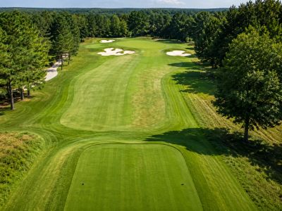
Golf course fairway and teeing area with managed turf, trees, and sand bunkers.

What You Receive

Turf Health Maps

Vegetation Index Analysis

Vegetation Index Analysis

Multispectral imagery can help identify potential overwatering, underwatering, drainage concerns, and uneven irrigation coverage across managed turf, helping superintendents prioritize areas for closer ground inspection.

Vegetation Index Analysis

Vegetation Index Analysis

Vegetation Index Analysis

Terra analyzes NDVI, NDRE, and other vegetation indices to evaluate turf condition and highlight spatial differences that may not be apparent from ground level. These patterns can help identify areas that warrant closer inspection for stress, irrigation variability, or other turf-related concerns.

Mapped Areas of Interest

Findings and Recommendations

Findings and Recommendations

Areas of potential concern can be mapped and paired with coordinates, helping superintendents quickly locate and inspect specific areas on the course.

Findings and Recommendations

Findings and Recommendations

Findings and Recommendations

You receive maps, observations, and coordinates for identified areas of interest, along with practical recommendations for follow-up inspection and monitoring. Findings are customized to the course’s conditions and management priorities.

Golf Course Drone Imaging and Turfgrass Analysis

Terra offers targeted-hole scans, full-course scans, and recurring monitoring programs. Services can be customized based on course size, priority areas, scan frequency, and management priorities. 


Request Golf Course Service Information

Social Media

Copyright © 2026 Terra Intelligence - All Rights Reserved.

Terra Intelligence LLC

bryce@TerraIntelGroup.com

(262) 235-3385‬ 

Grafton, WI

Southeastern Wisconsin

Drone scouting and monitoring services for agricultural, horticultural, turfgrass, and infrastructural operations

Powered by

This website uses cookies.

We use cookies to analyze website traffic and optimize your website experience. By accepting our use of cookies, your data will be aggregated with all other user data.

Accept